Log in
All resources
Create a design
1,785 Free Artworks of Maps Of The World
bibliothèque nationale de france
atlas minor gerardi mercatoris (1614, maps)
national library of poland
patrimonium 2 (project)
liber qvartvs contrafactur vnd beschreibung von den vornembsten stten der welt (zzk 0.32)
beschreibung und contrafactur der vornembster stät der welt, liber primus civitates orbis terrarum
atlas ou representation du monde universel t. 2 (1633)
engraving
grabados
fondo antiguo
everett d. graff collection of western americana
george f. cram
a & c black general atlas of the world
19th-century celestial maps
maps by thomas starling
1842 maps
cartography
maps
eran laor cartographic collection
jacques chiquet
18th-century maps of western europe
1754 maps of europe
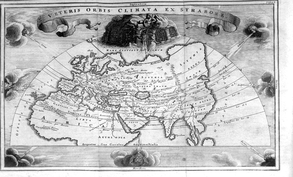
the story of geographical discovery
maps from books
atlas géographique des quatre parties du monde (delisle)
map of scandinavia by guillaume de l'isle (1706)
17th-century maps of the mediterranean sea
portolan charts made in the 17th century
atlas géographique des quatre parties du monde (delisle)
map of scandinavia by guillaume de l'isle (1706)
17th-century double hemisphere world maps
description de l'universe
antoine-françois tardieu
1800s maps of hispaniola
antoine-françois tardieu
1800s maps of hispaniola
17th-century maps of thuringia
atlas novus (blaeu)
old maps of regions of france
pierre françois tardieu
lehen (freiburg im breisgau)
baroque
sanson maps of asia
1670s maps of asia
description de l'universe
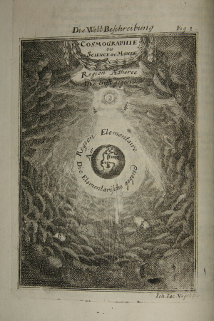
cosmography
1640s maps of the netherlands
maps by nicolaes visscher i
description de l'universe
cosmography
atlas ou representation du monde universel t. 2 (1633)
maps by hendrik hondius the younger
atlas ou representation du monde universel t. 2 (1633)
old maps of nuremberg
maps of saint paul's journeys
maps by pieter van der keere
atlas ou representation du monde universel t. 2 (1633)
1630s maps of virginia
maps of saint paul's journeys
maps by thomas starling
cartography
maps
1780s maps of the balkans
carl schütz
liber qvartvs contrafactur vnd beschreibung von den vornembsten stten der welt (zzk 0.32)
patrimonium 2 (project)
liber qvartvs contrafactur vnd beschreibung von den vornembsten stten der welt (zzk 0.32)
patrimonium 2 (project)
liber qvartvs contrafactur vnd beschreibung von den vornembsten stten der welt (zzk 0.32)
patrimonium 2 (project)
liber qvartvs contrafactur vnd beschreibung von den vornembsten stten der welt (zzk 0.32)
patrimonium 2 (project)
liber qvartvs contrafactur vnd beschreibung von den vornembsten stten der welt (zzk 0.32)
patrimonium 2 (project)
liber qvartvs contrafactur vnd beschreibung von den vornembsten stten der welt (zzk 0.32)
patrimonium 2 (project)
liber qvartvs contrafactur vnd beschreibung von den vornembsten stten der welt (zzk 0.32)
patrimonium 2 (project)
maps of alsace by guillaume sanson
1660s maps of baden-württemberg
juan de la cruz cano y olmedilla
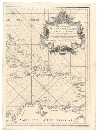
1750s maps of the caribbean
liber qvartvs contrafactur vnd beschreibung von den vornembsten stten der welt (zzk 0.32)
patrimonium 2 (project)
extra-ptolemaic maps of the americas (1540 design by münster)
german renaissance,northern renaissance
liber qvartvs contrafactur vnd beschreibung von den vornembsten stten der welt (zzk 0.32)
patrimonium 2 (project)
liber qvartvs contrafactur vnd beschreibung von den vornembsten stten der welt (zzk 0.32)
patrimonium 2 (project)
liber qvartvs contrafactur vnd beschreibung von den vornembsten stten der welt (zzk 0.32)
patrimonium 2 (project)
liber qvartvs contrafactur vnd beschreibung von den vornembsten stten der welt (zzk 0.32)
patrimonium 2 (project)
liber qvartvs contrafactur vnd beschreibung von den vornembsten stten der welt (zzk 0.32)
patrimonium 2 (project)
cornelius aurelius world map
atlas sive cosmographicae (gerardus mercator, 1630)
maps of liège by baptista van doetecum
atlas ou representation du monde universel t. 2 (1633)
17th-century maps of southeast asia
princess margriet of the netherlands in 1979
dutch baroque architecture
arnold's geographical handbook (1899)
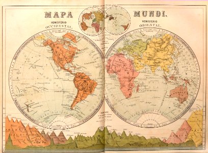
1899 maps of the world
semeuse stamps on covers and postcards (5c)
postcards of charleville-mézières
old maps of ukraine
atlas novus (blaeu)
arnold's geographical handbook (1899)
1899 maps of the world
travel
maps
atlas minor gerardi mercatoris (1614, maps)
maps of africa by mercator-hondius
atlas minor gerardi mercatoris (1614, maps)
maps of china by mercator-hondius
maps of the iberian peninsula by mercator-hondius
atlas minor gerardi mercatoris (1614, maps)
17th-century maps of the indian ocean
maps by willem and johannes blaeu
atlas minor gerardi mercatoris (1614, maps)
maps of moers by johannes mercator
atlas minor gerardi mercatoris (1614, maps)
maps of asia by mercator-hondius
atlas minor gerardi mercatoris (1614, maps)
maps of paradise by mercator-hondius
atlas minor gerardi mercatoris (1614, maps)
maps of abyssinia by mercator-hondius
atlas minor gerardi mercatoris (1614, maps)
maps of tartary by mercator-hondius
atlas minor gerardi mercatoris (1614, maps)
maps of virginia by mercator-hondius
atlas minor gerardi mercatoris (1614, maps)
maps of the caribbean by mercator-hondius
maps of the ottoman empire by mercator-hondius
atlas minor gerardi mercatoris (1614, maps)
atlas minor gerardi mercatoris (1614, maps)
maps of asia minor by mercator-hondius
atlas minor gerardi mercatoris (1614, maps)
maps of lake geneva by jacques goulart
18th-century maps of morocco
1700s maps of algeria
atlas minor gerardi mercatoris (1614, maps)
maps of mexico by mercator-hondius
atlas minor gerardi mercatoris (1614, maps)
maps of valencia by mercator-hondius
atlas minor gerardi mercatoris (1614, maps)
maps of portugal by fernando álvares seco
atlas minor gerardi mercatoris (1614, maps)
maps of south asia by mercator-hondius
atlas minor gerardi mercatoris (1614, maps)
maps of guinea by mercator-hondius
atlas minor gerardi mercatoris (1614, maps)
maps of the americas by mercator-hondius
maps of the magellan straits by lambert cornelis
atlas minor gerardi mercatoris (1614, maps)
atlas minor gerardi mercatoris (1614, maps)
maps of ceylon by petrus plancius
atlas minor gerardi mercatoris (1614, maps)
maps of andalusia by mercator-hondius
atlas minor gerardi mercatoris (1614, maps)
maps of provence by pierre-jean de bompar
atlas minor gerardi mercatoris (1614, maps)
maps of cyprus by mercator-hondius
1760s maps of the americas
1764 maps
maps of aragon and catalonia by mercator-hondius
atlas minor gerardi mercatoris (1614, maps)
maps of the malay archipelago by mercator-hondius
atlas minor gerardi mercatoris (1614, maps)
atlas minor gerardi mercatoris (1614, maps)
maps of barbary coast by mercator-hondius
pieter verbiest (ii)
maps from gallica
atlas minor gerardi mercatoris (1614, maps)
maps of japan by mercator-hondius
atlas minor gerardi mercatoris (1614, maps)
maps of the holy land by mercator-hondius
atlas minor gerardi mercatoris (1614, maps)
maps of europe by mercator-hondius
atlas minor gerardi mercatoris (1614, maps)
maps of castile by mercator-hondius
atlas minor gerardi mercatoris (1614, maps)
maps of persia by mercator-hondius
atlas minor gerardi mercatoris (1614, maps)
maps of morocco by mercator-hondius
atlas minor gerardi mercatoris (1614, maps)
maps of south america by mercator-hondius
maps of biscay and gipuzkoa by mercator-hondius
atlas minor gerardi mercatoris (1614, maps)
maps of italy by sanson and cordier
bibliothèque nationale de france
18th-century maps of antarctica
1741 maps
geographia universalis (1545) in the british museum
german renaissance,northern renaissance
maps of italy by sanson and cordier
bibliothèque nationale de france
beschreibung und contrafactur der vornembster stät der welt, liber primus civitates orbis terrarum
maps of london by braun & hogenberg
beschreibung und contrafactur der vornembster stät der welt, liber primus civitates orbis terrarum
maps of magdeburg by braun & hogenberg
beschreibung und contrafactur der vornembster stät der welt, liber primus civitates orbis terrarum
maps of granada by braun & hogenberg
beschreibung und contrafactur der vornembster stät der welt, liber primus civitates orbis terrarum
maps of antwerp by braun & hogenberg
beschreibung und contrafactur der vornembster stät der welt, liber primus civitates orbis terrarum
maps of lyon by braun & hogenberg
1301 - 1400 of 1,785
Next page
/ 18


![Gerardi Mercatoris and I. Hondii Atlas or Representation of the Universal World, and of the Parts of It, Made in Tables and Very Ample Descriptions. [t. 2].](https://cdn.creazilla.com/illustrations/10000421870/gerardi-mercatoris-and-i-hondii-atlas-or-representation-of-the-universal-world-and-of-the-parts-of-it-made-in-tables-and-very-ample-descriptions-t-2-md.jpg)
![Gerardi Mercatoris and I. Hondii Atlas or Representation of the Universal World, and of the Parts of It, Made in Tables and Very Ample Descriptions. [t. 2].](https://cdn.creazilla.com/illustrations/10001133003/gerardi-mercatoris-and-i-hondii-atlas-or-representation-of-the-universal-world-and-of-the-parts-of-it-made-in-tables-and-very-ample-descriptions-t-2-sm.webp)

![Gerardi Mercatoris and I. Hondii Atlas or Representation of the Universal World, and of the Parts of It, Made in Tables and Very Ample Descriptions. [t. 2].](https://cdn.creazilla.com/illustrations/10001569396/gerardi-mercatoris-and-i-hondii-atlas-or-representation-of-the-universal-world-and-of-the-parts-of-it-made-in-tables-and-very-ample-descriptions-t-2-sm.webp)


![Gerardi Mercatoris and I. Hondii Atlas or Representation of the Universal World, and of the Parts of It, Made in Tables and Very Ample Descriptions. [t. 2].](https://cdn.creazilla.com/illustrations/10000597422/gerardi-mercatoris-and-i-hondii-atlas-or-representation-of-the-universal-world-and-of-the-parts-of-it-made-in-tables-and-very-ample-descriptions-t-2-md.jpg)


![Beschreibung und Contrafactur der Vornembster stät der Welt, liber primus [Civities of the World], 1574](https://cdn.creazilla.com/illustrations/10000956434/beschreibung-und-contrafactur-der-vornembster-stt-der-welt-liber-primus-civities-of-the-world-1574-sm.webp)
![Beschreibung und Contrafactur der Vornembster stät der Welt, liber primus [Civities of the World], 1574](https://cdn.creazilla.com/illustrations/10001169640/beschreibung-und-contrafactur-der-vornembster-stt-der-welt-liber-primus-civities-of-the-world-1574-sm.webp)
![Beschreibung und Contrafactur der Vornembster stät der Welt, liber primus [Civities of the World], 1574](https://cdn.creazilla.com/illustrations/10001092955/beschreibung-und-contrafactur-der-vornembster-st-t-der-welt-liber-primus-civities-of-the-world-1574-sm.jpg)
![Beschreibung und Contrafactur der Vornembster stät der Welt, liber primus [Civities of the World], 1574](https://cdn.creazilla.com/illustrations/10000737984/beschreibung-und-contrafactur-der-vornembster-st-t-der-welt-liber-primus-civities-of-the-world-1574-sm.jpg)
![Beschreibung und Contrafactur der Vornembster stät der Welt, liber primus [Civities of the World], 1574](https://cdn.creazilla.com/illustrations/10001244045/beschreibung-und-contrafactur-der-vornembster-stt-der-welt-liber-primus-civities-of-the-world-1574-sm.webp)